Canada is a country of ten million square kilometers
covering many different geographical areas or regions.
These regions may include only one
or several different provinces.
The regions of Canada are
The Atlantic Region,
Central Canada,
The Prairie Provinces,
The West Coast
and
The North.
The capital of Canada is Ottawa, in Ontario.
Canadian Provinces and Territories
Canada has 10 provinces and 3 territories,
each with its own capital city
(in brackets)
Canada (Ottawa)
Alberta (Edmonton)
British Columbia (Victoria)
Prince Edward Island (Charlottetown)
Manitoba (Winnipeg)
New Brunswick (Fredericton)
Nova Scotia (Halifax)
Ontario (Toronto)
Quebec (Quebec City)
Saskatchewan (Regina)
Newfoundland (St. John's)
Northwest Territories (Yellowknife)
Yukon Territory (Whitehorse)
and our newest
Nunavut Territory (Iqaluit)
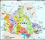
You will find a Map of Canada
And Links to Provincial and City Maps
HERE
Site will open in a new window


For all your graphic needs visit
iFREE Top Clipart and Graphics


Unlimited hits to your web site

LE FastCounter


Sign
My Guestbook
 View
My Guestbook
View
My Guestbook
NEW STUFF GRAPHICS
HERE
NEW -USEFUL PROGRAMS
HERE
 First Published Here March 6 1998
Copyright � 1998
First Published March 6 1998
H Carlton.
All Rights Reserved